1
2
3
LGTS
jest światowym liderem specjalizującym się w profesjonalnych rozwiązaniach Trackingu GPS. Następna strona »
LGTS
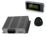
LGTS oferuje unikatowe rozwiązania dla firm transportowych, taksówek, policji, służ porzadkowych i pierwszej pomocy, rolnictwa, służ morskich. « Poprzednia Następna »
LGTS
Dlugoletnie doświadczenie, profesjonalizm i innowacyjność docenili klienici urzywając z zadowoleniem naszych rozwiązań . « Poprzednia
LGTS Group is a producer of high fidelity, precision, detailed digital maps. The maps’ quality is furthermore proven by the fact that they have been successfully used in car navigation, vehicle tracking, rescue and geomarketing.
LGTS maps is ensured by the firm’s considerable experience in the development of maps, which are continually updated, and above all the usage of own field measurements.
Maps is available with many vector formats as:
ESRI ArcGis, MapInfo and other.
| Our maps
features are
presented
within individual layers. These can be viewed individually, in any combination, or all together, depending on the needs of the individual user or application. Layers include: -Land shape -Land use -Land cover -Motorways & major roads -Highways, Streets -Urban, buldings -Home Addresses -Administrative boundaries -Ferry line -Power and water pipe line -Railways -Bus Station and Stop -Tram Station and Stop -Business locations (POI) -Public place -Frontier -Gazetteer |
 Belgium, Bruessel (zoom out) |
| Layer | Type | Description |
|---|---|---|
| adminareas | Polygon | Administrative areas representing national and subnational regions. |
| boundaries | Line | Borders between countries/states |
| buildings | Polygon | Building outlines |
| coastline | Line | Coastline (where applicable) |
| landuse | Polygon | Forests, residential areas, industrial areas, etc. |
| places | Point | Cities, towns, suburbs, villages, etc. |
| pofw | Point | Places of worship such as churches, mosques, etc. |
| poi | Point | Points of interest including schools, government offices, etc. |
| power | Point | Power generators, substations, etc. |
| powerlines | Line | Power lines |
| railways | Line | Railway, subways, light rail, trams, etc. |
| railwaystations | Point | Railway stations and halts, tram stops, etc. |
| roads | Line | Roads, tracks, paths, etc. |
| water | Polygon | Lakes, etc. |
| waterways | Line | Rivers, canals, streams, etc. |
Example maps printscreen
Poland, Szczecin

Poland, Wrocław

Germany, Berlin

Netherlands, Utreht

Panama, Panama City

Contact for samples of maps lgts@lgts.eu

&n